
Catalogue
Cigarette cards, John Player set of 50 appears complete of 'Wild Animal Heads' issued in 1927; another set of 50 'Motor Cars' issued in 1937. Very fine or better. (100)
Estimate $90
SOLD $60
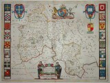
County of Oxford, double-page map of the county of Oxford by Joan Blaeu, Amsterdam, 1648, depicting numerous towns and rivers, with hand coloured cartouches and arms of the Oxford colleges, coloured illustration of Stonehenge on reverse with Dutch text, (38 x 50cm), in custom frame. Some folds, otherwise very fine.
Estimate $350
SOLD $350
Dorset, handcoloured county map of Dorset, by John Speed, dated 1662, published by Thomas Bassett and Richard Chiswell in 1676, includes towns, topography, cartouches and a view of Dorchester, alphabetical table of place names in Dorset on reverse, (38 x 51cm), in custom frame. Very fine and scarce.
Estimate $350
SOLD $390
Derbyshire, handcoloured county map of Derbyshire, by John Speed, dated 1666, published by Thomas Bassett and Richard Chiswell in 1676, includes towns, topography, cartouches and views of Derby and Buxton, alphabetical table of place names in Derbyshire on reverse, (38 x 52cm), in custom frame. Very fine and scarce.
Estimate $300
SOLD $320
Asia, handcoloured map of L'Asie, by Robert Janvier, c1770, engraved in Rue Saint Jacques Paris, printed in Bordeaux, includes Arabia, Russia and South East Asia, in French, (32 x 45cm), in custom frame. Some foxing, otherwise very fine.
Estimate $200
SOLD $100
Asia, handcoloured map of Asia, by Thomas Kitchin, c1780, published in George Millar's 'New Complete and Universal System of Geography', showing areas frpom Arabia to Russia and South East Asia, (38 x 33cm), in custom frame. Some foxing, otherwise very fine.
Estimate $150
SOLD $70
Asia, handcoloured map of L'Asie, by Robert de Vaugondy, c1778, engraved by E.Dussy, including Arabia, Russia and South East Asia, (27 x 23cm); China, India, Indonesia, handcoloured map by Robert de Vaugondy, dated 1778, engraved by E.Dussy, (28 x 24cm). Both very fine with only slight creasing. (2)
Estimate $100
SOLD $60
Captain Cook, an assortment of 18th century maps taken from Cook's first and second voyages, including the Sandwich Islands, Otaheite, a 'Remarkable Animal' (Australian Kangaroo), the Endeavour River New Holland (hand coloured), the West Coast of America, the Coast of Asia, the Society Islands, the Pitcairn Islands, Christmas Island, men & women of Kamtschatka, and others including Bougainville at the Magellan Straits, weapons of New Zealand, the East Indies, China, views of Siam. Very fine - extremely fine, in two collector's folders. (approx. 70)
Estimate $500
SOLD $400